KOMEIE, Shinobu
Professor, Faculty of Letters, Hosei University
Born in Shizuoka in 1968. Dropped out of the Comparative Culture division of the Ochanomizu University Graduate School. Obtained a doctorate in Human Sciences from Ochanomizu University.
After working as a full-time lecturer and assistant professor at Hosei University’s Faculty of General Education I, became a professor in the Department of Geography in the Faculty of Letters in 2007.
Specializes in historical geography.
FUKUI, Tsuneaki
Professor, Faculty of Engineering and Design, Hosei University
Born in Tokyo in 1970. Graduated from the Department of Civil Engineering, Faculty of Engineering, The University of Tokyo. Obtained a master’s degree and a doctorate in engineering from the University of Tokyo Graduate School.
After working for Shimizu Corporation, the University of Tokyo and the National Institute for Land and Infrastructure Management (Ministry of Land, Infrastructure, Transport and Tourism), became an associate professor at Hosei University in 2012 and a professor in 2013.
Specializes in landscape engineering.
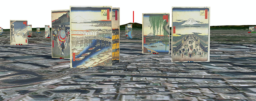
To collect data based on various historical materials on famous landscapes in Edo-Tokyo that people who lived during the Edo Period and Meiji, Taisho and Showa eras would have known. The collected data will be superimposed in space using a geographic information system (GIS) and visualized on a map. By visually representing spatial and regional information about famous landscapes that cannot be deciphered through textual information alone, it is possible to reconstruct the famous landscapes of Edo-Tokyo. The GIS used can also superimpose natural environment information such as topography and water systems on the map, as well as socioeconomic spatial information such as administrative divisions and traffic networks. This project’s purpose is to overlay famous landscapes with various other data to explore methods of two- and three-dimensional representation of the famous landscapes of Edo-Tokyo on digital maps, and then to share the findings with the public.
Digital maps have great potential, and when presenting the vast amount of data collected, there is room for many innovations in, for example, how information is processed and expressed in an easy-to-understand manner, in the representation of time, and in how distorted historical materials are presented. Collecting historical research under the premise that it will be used for digital maps will also require material collection and information handling methods appropriate for this purpose.
This project aims to develop new methods for Edo-Tokyo research and new ways of producing results using maps created with a GIS as a platform, as well as to develop implementation technology and utilization methods for expressing the results through collaborations between the humanities and sciences. As a concrete result of this project, the results of research on famous landscapes in Edo-Tokyo will be presented visually.